Hope Springs Eternal for Light Rail City
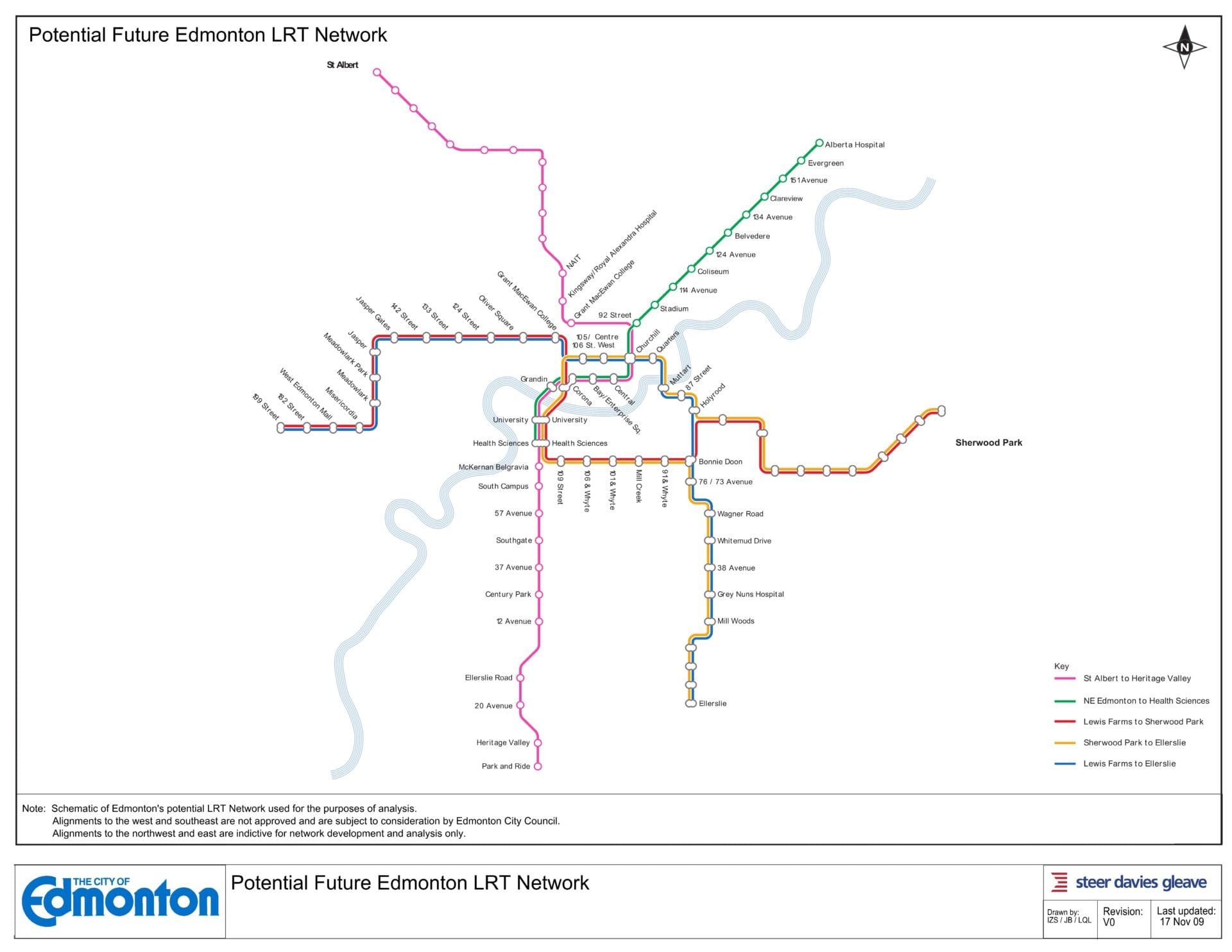
 In answering questions from Councillors during last week’s LRT routing debate, Transportation Department officials showed us a conceptual map of the full potential build out of our region’s LRT network to illustrate some points about connectivity.
It caught all of us by surprise — pleasantly so. I called it the ‘Hope Springs Eternal’ map. I also asked for a copy to share as it’s now in the public realm. Enjoy.
A couple of important qualifiers: this was for modeling purposes only, and does not presuppose Council’s ultimate decisions about alignments currently under debate (SE and W) or future projects (NW and E).
This map (prepared by our consultants Steer Davies Gleave) has roots in earlier decisions Council gave with respect to the overall LRT Network Plan as well as the ‘Urban Style’ system commitment of more frequent stops and low-floor technology. I wrote about these decisions previously here.
The issue at this level is not whether a given line or station go here or there, but how eager are we to bring a vision of this ambition to life? It’s certainly not up to the city alone — projects like this require the alignment of at least two and, properly, three orders of government. It will require the relentless pressure of citizens on Councillors, but more particularly on MLAs and MPs.
I’m game.
Here’s a thumbnail [updated Nov. 30 to correct some typos]; click on it to view at full size:

Looks tremendous! Go for it 100%
What a breath of fresh air!
Thanks for sharing Don. I think that’s a wonderful starting point, and that it is totally doable by 2040. Of course I’ve got some different ideas about where each of those different routes might go, the details of which will be posted to my website soon, but for now some initial thoughts:
1. The High-Floor (HF) Green line stops short at Health Sciences. What if it spurred along 87th (as was originally recommended) and formed the backbone of our West Medium-Rapid-Commuter-ish transit spine?
2. Both of the Red & Blue Low-Floor (LF) lines should then be split out to feed into that spine from various parts of the west end. One could come in from Lessard/Callingwood up past WEM towards SPR via Terra Lossa, and perhaps the other serves Westmount/Coronation before heading south towards Meadowlark/Rio Terrace.
3. I’ve been trying to look into track capacity issues with all these potential LRT corridors, and it seems to me that it’s quite common for two lines/routes to share the same track. However, with a two minute separation, it should be possible for 3 or more lines to share the same track during peak hours. In theory, within one 10 minute time frame, you could have 5 lines running 10 minute frequencies feeding into the same central track with the 2 minute headway between each. That said, it’s rare to see more than two lines.
i.e. In Frankfurt it looks like the U1, U2 and U3 lines share a common central line from the south before splitting into three in the north:
http://is.gd/4YDzT
4. I think it would be wise for us to plan a bonified long term system to serve not just 1.7 million Greater Edmontonians in 2040, but plan for spur lines & corridors across the city & region until 2110. How do we get there?
Again, I’ll be detailing my alternative proposals in the coming weeks on my website, but just imagine each one of those coloured routes (HF & LF) splitting into three distinct lines on either end.
Thanks again for your impeccably timed inspiration & keep up the good (smart growth) fight!
– Jordan
Wow, now we’re thinking like a big city. Imagineering rules the world!
The best part is the connections to St. AB and the Park. I’d love to still see the SE line shift over to 50th street (or even along 34th) and then down to a potential Beaumont route.
Following along the East of MWTC makes more sense, especially with an existing bus terminal. Since the on ground system is more flexible, it would be a better choice to go through the heart of the MW commercial district, rather than to skim the west of it.
As for the BD traffic circle, if they went under or around it to the west side of the circle like they did with the 111th intersection to reduce traffic impact, it would be best. They could shut down the West exit at Sir William place, and the North exit (towards the McNally traffic circle). That would make it a three way intersection for vehicular traffic so ultimately looking like the Groat rd one going down to Hawrelak park, with the LRT on the west side not interfering with the traffic flow to the SE.
This map seems to have more local stops which is great. As for the Kingsway stop, if the NAIT extension not already written in stone, they should have separate stops for the RAH and Kingsway Mall, as in the winter time, walking from RAH to Kingsway is quite a chill. Waiting for a bus from RAH to get to Kingsway seems pointless. To save on building a raised platform for the existing cars, the trains can run into ‘ditches’ when they arrive at stations, so they are on ground level with no need to build extensive infrastructure around it. Drainage would be around the same depth I think.
Whyte Ave can even have a concurrent line running with the existing Radial Railway cars, to add that historic look to Old Strathcona. It can be a main tourist attraction to the city like the ones in coastal Australian cities.
Another place that an LRT station can be placed is right where the LRT comes out of the ground btwn Churchill and Stadium. There are quite a few high rise residential towers within walking distance that would greatly help to push the planned development in the Eastern Quarters area.
Don,
I wholeheartedly support the ambition. It would be a tremendous idea for Edmonton to build-out a proper transit network. Of course, without follow-through in revised development strategies and regulations it will all be for nought.
To quote Daniel Burnham:
“Make no little plans. They have no magic to stir men’s blood and probably will not themselves be realized.”
ps, there’s a typo on the map. (see ‘quaters’)
Thanks for sharing! I was trying to track it down after hearing about it from Councillor Henderson, so this is great!
This looks amazing! I want it now!
What a beautiful sight! These eyes have moistened.
I was so excited in the idea of a ‘ditch’ design for the existing high-floor trains I mentioned in my comment that I created a model and a video for it here: http://www.youtube.com/watch?v=zQm0oq_tQe8
How about extending the LRT to the International Airport. Nisku and Leduc – the last two are growing industrial and commercial areas that have workers who live in Edmonton. This is really thinking big and future-oriented!
What you have in your hands there is the difference between Edmonton, sprawling suburbia and Edmonton, thriving city. Make it happen.
I realize that each line would have to undergo extensive consideration, but it seems odd that the green line should stop at Health Sciences. By the time this comes to fruition the U of A South Campus will be thriving and it doesn’t make sense to force northeast commuters to transfer in order to get there.
I assume the purple and green lines would be the only high floor lines, hence the second river crossing at the High Level Bridge. Since they would almost certainly go on top of the bridge, the Radial Railway that Lincoln mentions would be no more. I don’t think it’s necessary to turn Whyte into Fort Edmonton to maintain its status as one of Edmonton’s cultural hotspots.
With the extra stations, I think it’s worth considering adding express routes like in New York, particularly as the lines get longer.
I don’t care what it costs. Act with vision and get it done. If you do that, I will definitely be supporting you in the next election.
A line along Whyte Ave? Isn’t it just wrong enough that Council is considering (?) dividing Old Strathcona by a concrete ‘tunnel’ to a bridge over the river, then they have to even consider ruining (after allowing way too many bars to come in) what’s left of the ambiance of Whyte Ave. with an LRT line down the middle or wherever it may go? Sad…
I would love to see the amazing city this transit plan would service. The interconnectedness of this conceptualization is what i believe to be the source of its inspiration. More deeply connected and engaged communities is a city we all want to hope and work for, i hope we can continue to ‘Imagineer’.
make it happen….. please make it happen
http://www.edmontonjournal.com/business/Phoenix+suburb+swears+benefit+boulevard/2314734/story.html
Did you see this? About LRT’s positive impact on neighbourhoods in need of revitalization in Arizona.
I’ve heard a lot of skepticism over a proposed line down Whyte ave, but I think if you look at a few other cities you can see that low floor trams actually integrate pretty well with traffic.
Munich, Budapest, Amsterdam, and Zurich all make this type of system work well on busy pedestrian shopping streets.
Edinburgh in Scotland actually explored several options for their ‘Princes Street’ last year. This street has very similar amounts of traffic to Whyte Ave, and after their research they decided to use trams.
Here’s a google streetview link of Amsterdam:
http://maps.google.com/maps?f=q&source=s_q&hl=en&geocode=&q=amsterdam&sll=55.952395,-3.196672&sspn=0.002343,0.006968&ie=UTF8&hq=&hnear=Amsterdam,+North+Holland,+The+Netherlands&ll=52.373454,4.893621&spn=0.002541,0.006968&t=h&z=18&layer=c&cbll=52.373361,4.893508&panoid=qyLqLBRMWaSMA1lbcLeqBQ&cbp=12,346.2,,0,20.2
Cars, Pedestrians, Bikes, and Trams on chaotic roads. If they can make that system work on their roads, I’m sure we can do it on a grid system.